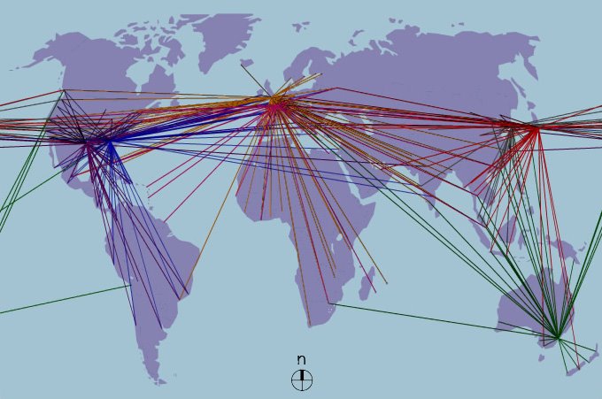
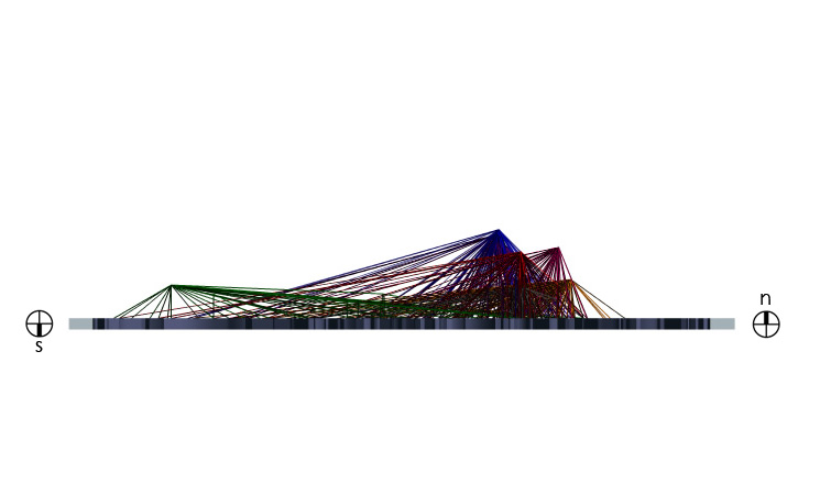
The following images are my mapimation revisions from suggestions made in Wednesday's studio. I have narrowed the focus simply to destination routes of some of the largest air carriers in each continent. For each airline, the main hub was taken and each major destination served from the main hub of a particular airline was simply connected with the hub. In the top view the map begins to develop a dominant area or "world" which each airline dominates. In a three dimensional view, the data has been mapped as topography, almost like a mountain range; the largest carriers have taller peaks. Giving the data a three dimensional presence creates an interesting new way to explore the map, it can be viewed in elevation and my hope is that well place sections will also help to reveal new patterns. Elevations views help to put into perspective what parts of the world certain airlines are more prevalent in. For instance, of the mapped airlines, British Airways seems to dominate the northern most part of the globe, while Qantas Airlines clearly dominates the southern hemisphere. In plan, while the graphic is still somewhat weak, one can make out distinct patterns and connections that are directly related to earlier historical movements. The imperial ages of France, Holland and England, for instance, become very obvious through their continuing ties. One can see a strong correspondence between these nations and thier current and former territories.
Seven of the world's 20 largest airlines have been mapped, the colors coordinate to the airlines as follows: blue=Delta Airlines, purple=American Airlines, magenta=Air France/KLM, red=Japan Air, orange=British Airways, green=Qantas Air, and gray=Korean Air.
The next step will be to find a way in which animation can make certain patterns and the overall mapping clearer to understand. I also hope to add a volume to each of the flight paths rather than just a line. I hope that solid mass will create an airline mountain range across the globe which can be cut in different areas to study in section, in plan, in elevation, and hopefully also from a perspective point of view. Let me know if you have any suggestions on what you think could help the mapping.


No comments:
Post a Comment